One of CRASL's flagship projects is what we call the "Underground Jerusalem Heritage Trail".
Since 2003 we've been working on sub-surface GPR studies in the Old City
of Jerusalem. Historically this was the Upper City prior to the Roman
Destruction. By piecing together non-invasive
studies in public areas we can learn more about the history of
this ancient location without disturbing its day-to-day bustling
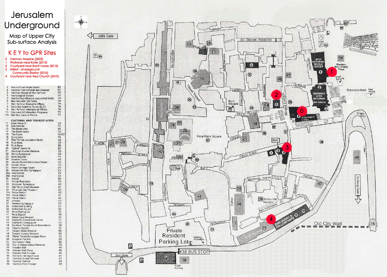
activities. Click for an enlarged map
and details of the areas we have surveyed so far.
Since 2003 Dr. Jessie Pincus has been working to create a sub-surface map of the
Upper City of Jerusalem prior to the Roman Destruction, first begun as
part of her undergraduate research. The initial surveying and extensive
GPR work was completed at the Church
and Hospital of St. Mary of the Teutonic Knights that sits above the
Roman Destruction and at the apex of
what was the remains of the historic Upper City.
During this previous summer 2010 season we added 4 new grids of GPR
acquired data of areas at the same level as the Roman destruction of
the city in 70 CE. Portions of this area were later utilized during
the Byzantine period in the creation of the famous Nea Church. These
surveyed areas link to the surrounding archaeological sites and thus
sub-surface stratigraphy of the city can be continued. After the city
was damaged during the 1967 war, intense archaeological excavation was
completed. Many areas were also simply filled in for preservation and
will not be further excavated in coming years. By creating a sub-surface
underground map of the cavities that many buildings are built upon,
we are able to invest in heritage tours of the city's destruction by
the Romans in 70 CE, in addition to potential prevention of collapse
of buildings that people are presently living in on top of the yet
unknown cavities they are built upon.
Working in close collaboration with members of the Old City municipality,
this project has tremendous value in the field of city planning and facility
management. With the enormous increase of tourists to the Old City of
Jerusalem in coming years and the historical importance of the sites there
will be numerous opportunities for academic collaborations as this project
unfolds.
We can't do it without you! Help us fill in our map over the next three years.
We are seeking funding and support to complete this worthy project. A detailed proposal is available and can be supplied upon request.
Help us preserve the heritage which lies beneath our feet at the
center of Jerusalem, and the focal point of Western Civilization
for the last 2000 years.
Contact us
if you are interested in participating!
Donate Here!