Tell es-Safi, Israel, Summer 2004 - 2005
Tracking the Trench
Plotting the Course of the Trench: Ground Truth Study 2005  Return to Whole Trench Study |
Ground Truth Study 2005
Return to Whole Trench Study |
Ground Truth Study 2005 
Return to Whole Trench Study |
Ground Truth Study 2005
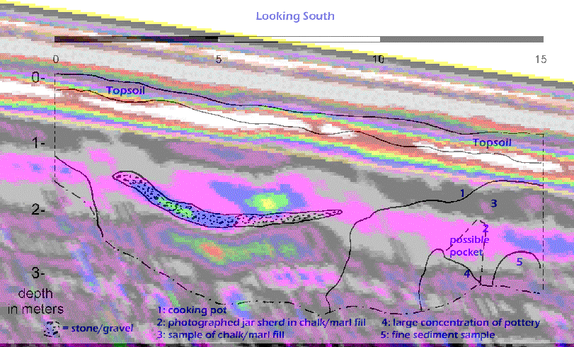
In August 2005, a backhoe was brought to the Tell es-Safi archaeological site. BIU doctoral candidate Jessie Pincus with the Mnemotrix team led the ground-truth study along with Dr. Aren Maeir, the Chief Archaeologist of the site, and Dr. Oren Ackermann, Geomorphologist of T. Safi. The aim was to ground-truth through excavation a portion of the results from the previous 2004 season.A 15 meter ground-truth trench was dug in an east-west direction to a depth of about 3 meters. This trench was just north of GPR Grid 1, centered in Grid 5, and extended partially into Grid 2. We chose this location as it was perpendicular to the general trend of the anomalies heading north, and was between two points running N/S on the anomaly map.
After doing a geological profile of the 2005 ground truth study, we merged the information found with the GPR data we had collectd in 2004, and found significant matching information. The details of what was found can be seen in the full report.
The figure below is a merging of these two types of data, georeferenced to each other in ArcGIS by focusing on the gravel feature. This gravel stands out in the GPR data because it is significantly different from the surrounding chalk/marl matrix. The topsoil layer also is imaged well with GPR and corresponds to the sharp boundary that we saw in the field between the topsoil and chalk/limestone fill of the sub-surface.
Overall an excellent validation of the GPR technology in a GeoArchaeological setting was again confirmed.